City Studies Dangerous Intersections, Including Wisconsin and M
By Mark LiebermanCurrent Staff Writer
The D.C. Department of Transportation is working to research and enact improvements for five of the city’s most dangerous, accident-prone intersections, including two in Northwest, according to a new report released Thursday.
The report gathers information from site visits of the intersections arranged by Ward 3 D.C. Council member Mary Cheh in August and September. The two Northwest intersections are Wisconsin Avenue and M Street and 14th and U streets; the other three sites are located in Northeast.
Cheh, who chairs the council’s transportation committee, selected the five intersections from a list designated “high-crash” by the transportation agency. The report also includes data on crashes at the intersections from Jan. 1, 2012, to Aug. 1, 2015.
Cheh said she organized the site visits with the goal of making the issues at each intersection easy to understand, and to facilitate a dialogue between the government and the public. In previous years, she said, she got the impression the D.C. government made promises to improve traffic safety but didn’t deliver on them.
“The sense was that maybe we don’t focus in particular in a way that allows us to have specific recommendations and actions and a plan,” Cheh told The Current.
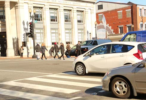
The Wisconsin and M intersection, in the heart of Georgetown, serves as a hub for private vehicles, buses, pedestrians and bicyclists. Between 2012 and Cheh’s site visit, 36 injuries were reported at the intersection from pedestrians and bicyclists alike, including two disabling injuries, according to the Transportation Department report. The intersection is also notorious for a 2005 fatality, when volunteer police officer Joe Pozell was struck by a car while directing traffic.
Causes for the congestion and confusion at the Georgetown intersection include quick intervals between signal switches; frequent crossing outside the crowded crosswalk lines; and pedestrians running for buses along both streets. Multiple instances of cars running red lights and drivers becoming confused at the turning options also contribute to the high risk, the report says.
The document lays out some potential improvements, like temporary curb extensions, expanded crosswalk boundaries, red light cameras and further deployment of traffic control officers.
Ward 2 D.C. Council member Jack Evans said in an interview that he jogs through that intersection every day and often drives there as well.
“The biggest issue as a driver is when you’re going south on Wisconsin. It’s virtually impossible,” Evans said. “They have people walking at the same time as the right signal. It’s so crowded that you can’t make the right turn.”
Evans said he thinks the recently installed left-turn signal on the eastbound side of M Street has helped. He also supports the idea of more traffic control officers.
Georgetown advisory neighborhood commissioner Bill Starrels said the crosswalk has been problematic for many years. He believes traffic control officers and red light cameras are particularly critical as solutions. “They do help in calming things down and making things safer for pedestrians,” Starrels said.
Meanwhile, the 14th and U intersection is the crossroad between two bustling commercial and nightlife-centric corridors. Two fatalities have occurred in this location since 2012. Half of the more than 200 collisions at the site happened between 7:30 p.m. and 6:30 a.m., the report says.
In terms of solutions, the intersection will be part of the $10 million 14th Street streetscape project, which will outfit the corridor with new lights, sidewalks, ramps, traffic signals and pavement. The project is set to begin construction this fall, according to the report.
The document also lists several potential short-term fixes that will be discussed during the next couple of months and implemented by May. Options include exploring photo enforcement of traffic violations; improving enforcement of bike lanes to prevent errant vehicle parking; and evaluating the potential for installing high-intensity activated crosswalk, or HAWK, signals in the area.
Cheh’s office arranged the intersection visits with representatives at various levels of D.C. government: Metropolitan Police Department officers, the Department of Transportation, advisory neighborhood commissioners, D.C. Council staff, and advisory councils for pedestrians and bicyclists. Members of the public were also invited to join in and share the issues they faced while crossing.
“It was this exchange of information back and forth,” Cheh said. “It was really very valuable, and I think people really enjoyed the opportunity.”
In the coming months, Cheh said she’ll do her best to keep the public abreast of agencies’ progress on specific reforms at hand. In the past, she said, recommendations without in-person site visits have tended to be too general.
“People don’t become mobilized unless they have a specific plan,” Cheh said. “That’s what I was hoping for with this. And so I’m optimistic.”
The other intersections the report identifies are 1st Street and Massachusetts Avenue NE; Bladensburg Road and New York Avenue NE; and Minnesota Avenue and Benning Road NE. The full report can be viewed at tinyurl.com/DDOTReport.
This article appears in the Jan. 20 issue of The Georgetown Current newspaper.